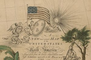
This map, published in New Haven, Connecticut in 1784 by Abel Buell, is the first map of the then newly created United States that was compiled, printed, copyrighted, and published in the United States by an American. The full title is, A New and Correct Map of the United States of North America: Layd down from the Latest Observations and Best Authorities Agreeable to the Peace of 1783.
The map shows the fledgling nation as it existed just before the ratification of the Constitution. At this time, the states had not yet given up their claims to all lands to their west, making what modern Americans would consider to be strange-looking borders. Additionally, many eastern U.S. states did not exist yet, such as Vermont, but the place names are present.
This map, on display in the Library of Congress, is considered to be the best preserved of only seven copies known to still exist. The Library acquired this map in 2010, and it is on display in the David M. Rubenstein Treasures Gallery, in the Thomas Jefferson Building.